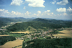
Geography:
- a beautiful foothill village situated on the boundary of the Strážovské hills and the Bánovská hilly country, where the Bebrava river leaves the grip of the Strážovské hills and twists to the south.
- terrier of the village has its acreage of 1022ha, thereof 282ha ploughland, 135 ha meadows and grazing-lands, 530ha forests
- a broken terrain, the highest point Baské, 955m (heigh) above sea level, the lowest point 244m (heigh) above sea level
- in the north of village bounded by a karst plateau Veľké Lúky - settled to the year 1985
- distance - 27km to the west of Trenčín, 14km to the north of Bánovce nad Bebravou
|
Settlement:
- Settlement of village from the Primeval Age. Reason - good position at the spring and a crossroad.
- a rich archeological site from the New Stone Age (2000 BC)
- a burial site from the New Stone Age (1300-900 BC) with many grave mounds and burnt graves
- the first written mention from the year 1208 as "zem Basna", from 1832 Krasnaves, from 1927 Krásna Ves
Population:
In the first years after war lived more than 1000 inhabitants in the village,
nowadays 501 inhabitants.
Flora and fauna:
Flora and fauna, mushrooms and bacteria are varied because of different natural
conditions. Flora - specific variety of endangered and rare kinds.
If you want to know something else, visit Krásna Ves and its surroundings.
Organisations of Microregion Podhorie offer you their services.
Translation: Hošková
|