Access: by train, by bus
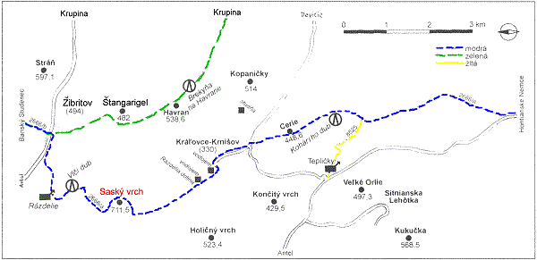
Starting point: Hontianske Nemce, Saský vrch is situated between Hontianske Nemce and Banský Studenec on the blue-signed path.
Itinerary is mid-strenuos, lasts almost five hours.
Map: the Štiavnické hills (No.8), the new map No. 138.
We pass the village in direction of Banská Štiavnica, at the end of village among houses
right. Through meadows in the valley to its end then left through forest on the crest.
By a woodland path we go to the meadow where stands the famous Kohári oak tree (
a protected tree which rested the Earl Kohári under). From the oak we walk right through
forest to a tourist path leading on a narrow crest.
From this point we go down to Kráľovce - Krnišov, near a church to a bus station. From
that place up through the village near a bell-tower, then near an agricultural
cooperative to the waterworks at the beginning of the valley Rázdelie.
We leave a bituminous road left through the brook and then under the settlement we set
out right in the valley. We move up to a forlorn meadow, then we traverse to a withered
apple tree at the upper end, right into the forest and we climb up to a woodland path.
A sign indicates right and then after 500m branches off to a hill by an old woodland
path and later by a path to a hunter's path. Right we traverse Saský vrch (hill)
approximately in 20 minutes we branch off left to the peak.
When we glance around, we will find rests of an old lookout which Andrej Sládkovič had
written 100 years ago about.
By Jozef Lupták
Map by Jozef Kollár
Krásy Slovenska No. 3-4/2001
|
Translation: Hošková